

Cities the world over have complicated and conflicting relationships with the bodies of water on which they were built — at once drawing life and commerce from them, while battling their floods, pollution, and the ghosts of industries and peoples past. Evansville is no different.
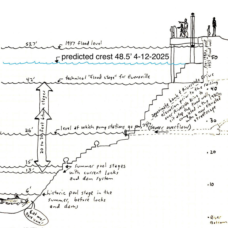
While the great flood of 1937 is almost 90 years behind us, it lives on in legend, lore, and the shared history and memory of our community. Devastation hit cities upriver first — Cincinnati, Ohio, then Louisville, Kentucky, where more than half of the city was underwater. Over a million people were affected up and down the navigable waters of the United States.
Here in Evansville, the city was inundated. Entire neighborhoods were submerged, prompting the evacuation of thousands of people and spurring long-term changes in flood control infrastructure. A massive federal response followed. The U.S. Army Corps of Engineers and the Works Progress Administration (WPA) led the charge, funded through the Flood Control Act of 1936 and the River and Harbor Act of 1938. The WPA played a crucial role in both cleaning up after the flood and constructing the city’s long-term defenses, including the levee system we rely on today.
Once the floodwaters receded, hundreds of WPA workers were mobilized to clear debris, sanitize streets, and restore essential infrastructure. Public buildings were disinfected, roads repaired, utilities rebuilt — all vital efforts during the cold winter months when disease and exposure were real threats. With many residents displaced or out of work, the WPA’s efforts weren’t just practical — they were lifesaving.
In the aftermath, the federal government prioritized long-term protection. The WPA supplied the labor and funding to construct Evansville’s extensive levee system, now spanning more than 26 miles and costing $55 million. Workers moved earth, poured concrete, and supported engineering efforts at a time when local resources were stretched thin. This wasn’t just about building a wall against the river — it was about building resilience and creating jobs when they were desperately needed. The WPA was a lifeline, first helping clean up a drowned city, then fortifying it for the future.
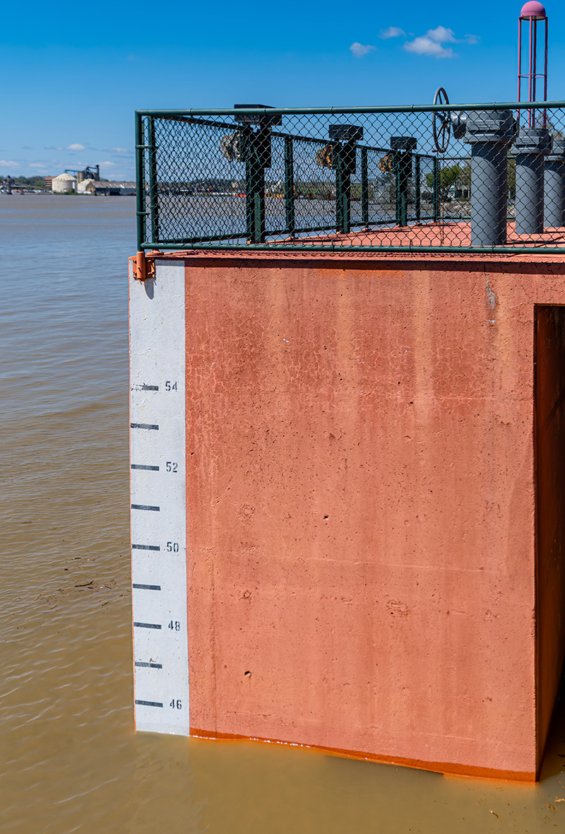
Today, after historic rains across the Ohio River Valley, we’re watching the river rise toward a predicted crest of 48 feet. That’s half a foot higher than the flood of 1997, enough to overtop the highway at the old lock and dam in Newburgh, Indiana and enough to bring serious damage to homes in Union Township. In Evansville, it’s already causing problems in the Pigeon Creek watershed along Lynch Road. (Editor’s note: Vanderburgh County officials announced, starting April 11, the closure of Burdette Park on the city’s West Side due to floodwaters.)
With all this river watching, astute observers may notice something else: a sudden drop in barge traffic. It’s not that the push boats can’t navigate these swollen waters — they can — but the flood levels lift barges too high to fit beneath the conveyors that load them. If they can’t load cargo, they can’t earn revenue, so many vessels simply wait it out until the waters recede.
For thousands of homes and tens of thousands of people, the good news is our levee. With more than 20 miles of earthen wall and 900 acres of system to maintain — including 32 pump stations capable of draining an Olympic-sized swimming pool in seconds — the Evansville Levee Authority works year-round to keep the area safe. When flood events like this one strike, their crews are out in force, clearing drain screens and flap gates, monitoring pump station data, mowing grass on schedule, and erecting floodwalls at Riverside Drive and Northwest First Street near Bally’s Evansville and the USS LST-325.
The work begins well before we reach flood stage. As early as 26 feet, levee staff already are on high alert, monitoring stormwater to ensure it enters the river — and not local sewer systems. By 33 feet, still well under flood stage, the levee’s computer systems kick in for extra oversight. These controls, one of the most advanced in the country, set Evansville’s system apart. After Hurricane Katrina, ours was the first levee in the nation to be recertified, and it remains one of the most computer-controlled levee systems in the U.S.
Technology aside, it’s also a testament to strong original design. Evansville’s levee can withstand waters up to three feet higher than the catastrophic flood of 1937. While Smothers Park in Owensboro, Kentucky, already is underwater, Evansville’s riverfront still has about nine feet of protection to spare.
This system doesn’t just keep our streets dry and our toilets flushing — it also saves us money. Because of the levee, thousands of homes in Evansville are excluded from FEMA’s floodplain maps, sparing residents the added burden of $100-200 in monthly flood insurance premiums. That’s real money staying in the local economy, supporting families, and powering consumer spending.
As the river swells to levels not seen since 1937, take a moment to thank the federal government, the Works Progress Administration, and today’s dedicated levee workers — those behind the scenes with boots on the ground and data on the screens. They deserve our admiration and support. We are cheering them on, just as the waters rise.
Philip R. Hooper is a real estate agent with Berkshire Hathaway and has a passion for history, architecture, and community events. He, wife Amanda, and their two children moved to Evansville from Indianapolis in 2012.